Beautiful Iceland---- Self driving tour around Iceland on National Day 9, 2019
Days: 9 days
Time: September
Per capita: 20000 yuan
With whom: husband and wife
Play: Humanities, poor travel, self driving, semi free travel, photography, free travel
The author went to these places
Watner Glacier National Park
Mihu
Glacial lake
Mount sneiffel
Namafjall geothermal
crater
Blue lake
Black beach
Reykjavik
Golden falls
Detti falls
Kravla volcano
Waterfall of God
Singhville National Park
Geyser Geyser
Serialand falls
Midals ice sheet
Highway 1
Published on 2020-10-19 10:50
Catalogue 1, preface 2, itinerary 3, Aurora 4, Golden Circle 5, inland highlands of landmannarauca 6, jigger glacier 7, Varna Glacier National Park 8, Mihu area 9, Mount Sinai Peninsula 10, travel information 1, preface Iceland, an island of ice and fire, with its boundless glaciers and terrifying volcanoes, is proud to occupy the North Atlantic, emitting melancholy and gloomy atmosphere Lonely charming temperament, silently looking at the North Pole. Iceland, with its gorgeous Aurora, unique landscape, changeable landforms, colorful colors and rich levels, shows the power, grandeur and beauty of nature, and records the changes of the earth and the flow of time. It is said that an important reason why Iceland is popular with tourists is that it is not like the earth, but more like an alien!
Some friends recommended to visit Iceland for a long time, but it was not included in the plan until an alumni said that he should go early, otherwise some unique landscapes might disappear forever because of climate warming, and it would be hard to see them again! We chose to leave one week before the National Day in 2019, with a total of 9 days. Before and after the national day, it should be a good choice to see the landscapes in different climates: green, gold, snow peaks, glaciers. Photo highlights: skafta Mountain Nature Reserve:
Diamond ice Beach:
Glacial lake of jagul Salon:
Iceland Aurora:
Anastabi scenic area:
Mount sneiffel National Park:
Church Hill, Church Hill waterfall:
Feather Canyon:
Jigger Glacier:
Landmannarauca inland Highlands, colorful Mountains:
Geyser:
Namafjall geothermal Park:
Hindley National Park:
Stora Crater Lake:
Huier crater:
Rhinoceros stone with subtle and slight warping:
Aerial photo of Blue Lake Hot Spring
Hagapa falls:
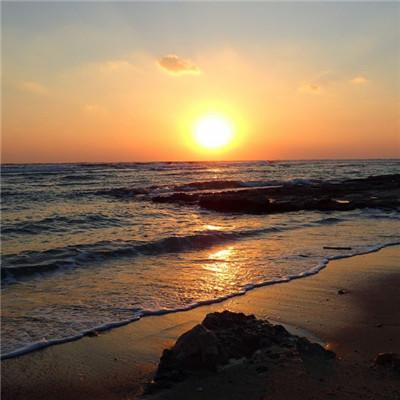
Black beach:
Scenery along the way:
"Extraterrestrial" landforms:
2、 General route of the tour around the island:
D1, Reykjavik Airport - Blue Lake - Reykjavik D2, Reykjavik - singwidley National Park - Gesher geyser - Golden Waterfall D3, golden waterfall - hjalparfoss double waterfall - landmannarauca inland highland D4, landmannarauca - gig glacier - skoga waterfall - sorheima glacier - Church Beach - Black Beach - Vik D5, Vick feather gorge skafta Mountain Nature Reserve - vatna glacier lake D6, vatna glacier lake - vestrahorn - Mihu D7, Mihu - Daiti waterfall - Clara volcano - stora Crater Lake - namafjall geothermal - GRJ ó tagj á Cave - Huier crater - Black Castle - Shenzhi waterfall - rhinoceros rock - Straw Hat Mountain (Church mountain) D8, Straw Hat Mountain - Church mountain waterfall - alnastapi village - sneiffel Volcano National Park - Reykjavik airport D9, Reykjavik Airport - Denmark (starting the 8-day self driving tour of the three northern European countries) 3. Aurora Iceland is the only country in the world, and the whole country is in the aurora belt, so it is easy to see the aurora everywhere in Iceland. It is said that lovers will be happy all their lives as long as they see the aurora together. Married, guarantee that there will be no third party. Backstepping has not been verified! Aurora is a brilliant light formed by charged high-energy particles from the magnetosphere and solar wind, which are guided into the earth's atmosphere by the geomagnetic field and collide with atoms in the upper atmosphere (thermosphere). There are three conditions for Aurora: atmosphere (clear sky), magnetic field and high-energy charged particles. To see the aurora, you'd better download the aurora app in advance. It will tell you the aurora parameters and the probability of seeing the aurora in the next few days. If you can see it, the software will remind you in advance on the same day. That's how we were reminded. In Iceland, most of the days are cloudy and rainy. The last night is sunny at the capital airport. Fortunately, our hotel is located near the airport. Full of expectation, we need to know that the aurora may not be seen on a sunny day. I was having dinner at about 9:00 p.m. when I turned on my mobile phone, I suddenly thought of a prompt tone. When I turned it on, it was a software prompt that night. From 9:25 p.m., I could see the aurora. The probability is 20%! This probability is very conservative. It should be 80%. So immediately contact the landlord, get confirmation, and tell us where to watch. So we went straight to the observation point. When they arrived, they found that many cars had been parked and many tourists had gathered. Many come from Taiwan and Hong Kong. By the time we arrived, the aurora had already appeared, but it was very weak. In a hurry, he quickly set up a tripod, very excited, for the first time in his life! This is the beauty of my dream! After a short wait, the aurora began to appear in various shapes, colors and movements. At about 10 o'clock in the peak period, large Aurora appeared many times, which attracted the collective cheers and exclamations of the tourists! I've seen the aurora effect in the aurora video and pictures before, but this time I've seen it. It's a great trip to get what you want! A successful conclusion to Iceland. The aurora ends around 11 p.m. and we don't stay up late like many people who are chasing the aurora. Fortunately! Aurora in the sky constantly change shape, color, drift in the air, like a dream! Beautiful! Tried to use a mobile phone camera, completely unsuccessful, estimated to use a camera. In particular, none of the aurora pictures I took can reflect the dreaminess and beauty of the scene. Of course, green is not the true color of Aurora, it is the effect of long exposure. The effect of the aurora shot by the mobile phone is very poor. When shooting with SLR, you need to set the exposure combination manually, adjust the aperture to the maximum and ISO to the maximum, so as to reduce the exposure time as much as possible and obtain clearer Aurora details. The exposure time I used was 10-30 seconds. There was no detail at all. It was just a strip of light. I believe it will be better next time. Share some photos of Aurora shot this time:
4、 Golden Circle 1, blue lake Iceland blue lake, also known as blue lagoon, is a famous geothermal hot spring in Iceland. Blue lake is located in glindavik, Reykjanes Peninsula, southwest of Iceland, 13 km from kevlavik International Airport and 39 km from Reykjavik. The blue lake is formed by some volcanic lava with a water temperature of about 37 – 39 ° C. The lake water is rich in minerals such as silicon and sulfur. In blue lake hot spring, can help treat some skin diseases, such as psoriasis. We arrived at Reykjavik airport after 3:00 p.m., picked up the car and went directly to the blue lake hot spring. Then we went to Reykjavik city. By the way, the rhythm was very compact. Tickets are very expensive. Aerial photo of Blue Lake Hot Spring
Blue lake
Blue lake
Iceland
Blue lake
2. Singwedley National Park singwedley National Park( Þ Ingvellir National Park is a world cultural heritage. The earliest parliament in the world was held here. Singhville National Park is located at the edge of the huge rift caused by the separation of the North American plate and the Eurasian plate. It is very magnificent and is a world heritage site. Now the rift is still separating at a rate of two centimeters a year. In the middle of the larger cracks, there are lakes and rivers with clear and green water.
ingvellir National Park
ingvellir National Park
ingvellir National Park
ingvellir National Park
ingvellir National Park
ingvellir National Park
ingvellir National Park
Geyser geyser geyser geyser geyser geyser geyser geyser geyser geyser geyser geyser geyser geyser geyser geyser geyser geyser geyser geyser geyser geyser geyser geyser geyser geyser geyser geyser geyser geyser geyser geyser Geyser. The whole eruption process can be seen from the vent, especially before the eruption, the boiling water ejected to form a bowl, and then the water column in the middle turned into steam and went up about 20 meters in the air.
Geyser
Geyser
Geyser
Geyser
Geyser
Geyser
Geyser Video:
4. Golden waterfall
Gullfoss is one of the most spectacular waterfalls in Iceland, with a total height of 32 meters and the longest drop of 21 meters. It is one of the most popular tourist attractions in Iceland and a part of the golden triangle around Reykjavik.
Golden falls
Golden falls
Golden falls
5. Hjalparfoss the famous hjalparfoss, also known as double falls, is in the south of Iceland. It's very convenient on the way to landmannarauka. There are volcanic rocks, moss and green meadows. It is formed by the crossing of the waterfalls of two rivers. The lava flowing through the river was originally born from Hekla volcano, which is the most active and unpredictable violent volcano in Iceland. It has erupted more than 20 times and is known as "the gate of hell".
6. Seljalandsfoss Seljalandsfoss is a waterfall with a vertical height of 60 meters in the southwest of Iceland. It is located on the seljalands River, about 30 kilometers west of Skogar, between skoafoss waterfall and cerfoss. It is the most photographed waterfall in Iceland. It has appeared many times in books and magazines. Behind the waterfall, at the bottom of the cliff, there is a path for tourists to cross. South of the waterfall is Iceland's No.1 Island Road, with convenient transportation.
7. Sk ó gafoss is located in the south of Iceland. It is 60 meters high and is one of the largest waterfalls in Iceland.
Skoga falls
8. Solheima glacier solheima glacier is an ice tongue flowing out of the midars ice sheet, which is the fourth largest glacier in Iceland. Unlike other glaciers, it's not as white or blue as people think. Because there is an active volcano under the solheima glacier, and the volcanic ash erupted covers the whole glacier, the ice here is fused with the volcanic ash, showing a white and black color.
Solheima glacier
Solheima glacier
Solheima glacier
Solheima glacier
Solheima glacier
Solheima glacier
Solheima glacier
9. Black beach and church beach are located in Vick town in the south of Iceland. They are connected and separated by arches. Black beach was listed as one of the ten most beautiful beaches in the world by islands magazine in 1991. There are many active volcanoes in Iceland, and the "sand" of the black beach comes from volcanic lava. After being carved by sea breeze and waves, the black basalt turns into black sand. Of the several black beaches in Iceland, Vick is the most breathtaking. Although the sand here is black, it is transparent and pure, without impurities. At a glance, it is flat and deep, and does not affect the clarity of the sea. Hold a handful of black sand and let it slip between your fingers, but your hand won't be stained with a trace of black. There are many strange shaped rocks on the black beach. A long dike made of stones extends into the sea. There is a lava mountain not far from the beach. It is straight and abrupt, adding a lot of mysterious and strange atmosphere. Many crew will choose this black sand and white waves place to shoot scenes of other planets. According to local legend, the beach blackened by witches' magic is a natural thing, and the columnar joints under the cliff seem to be made by nature. In the face of the uncanny workmanship of nature, no matter how much human creation is dwarfed. Church beach is famous for dihorari's natural arch. It is a coastal reef Cape near Vick Town, the southernmost tip of Iceland, with an arch height of 120 meters. It is made of marine eroded black basalt.
Black beach
Black beach
Black beach
Black beach
It is said that the reason why the hexagonal strip formed after the eruption of heishatan volcano is due to the shrinkage of volcanic rock and the formation of cracks. The regular polygon that can fill the whole plane only has regular hexagon and regular quadrilateral, but under the same area, the side length of regular hexagon is relatively small, so the volcanic rock is hexagonal
Black beach
Black beach church beach network photo:
On the way to black beach:
10. Feather Canyon (FJA) ð R á rglj ú fur) FJA ð R á rglj ú fur) is located in the southeast of Iceland, with a depth of 100 meters and a length of about 2 kilometers. On both sides are steep rock walls, narrow and curved. The stone bed is said to have a history of 2 million years. Fja ð The R á river flows through the mountains of geirlandshraun, runs down the cliff in the canyon, and finally falls into the skaft á river. Today, the river is not deep enough for tourists to walk through the canyon, but sometimes they need to wade. If you go deep into the canyon and meet a waterfall, you need to turn back the same way. So many people choose to look down on the upper edge of the canyon along the footpath to see the wonders of the canyon.
Feather Canyon
Feather Canyon
Feather Canyon
Feather Canyon
Feather Canyon
Feather Canyon
Feather Canyon
Feather Canyon
Feather Canyon
Feather Canyon
Feather Canyon
Feather Canyon
Feather Canyon
11. The bat mountain vestrahorn is in the southeast of Iceland, on the edge of the sea. There is a majestic vestrahorn mountain, with the highest altitude of 450 meters and a history of about 8 million years. Although it's not high, it has style and style. It's like a bat with open wings flying towards us. So I prefer to call it "bat mountain".
Mount vestrahorn
Mount vestrahorn
Mount vestrahorn
Mount vestrahorn
Mount vestrahorn
Mount vestrahorn
Mount vestrahorn
Vestrahorn mountain network photo:
5、 The inland highlands of landmanalaca, an inland highland at the southern tip of Iceland, near the Hercules volcano. The area has many unusual geographical features, colorful rhyolite mountains and vast lava areas. Many of the surrounding mountains are rich in color, including pink, brown, green, yellow, blue, purple, black, and white. Landmannarauca, scenery on the road:
Landmannarauca, open air Spa:
Landmannarauca
Landmannarauca
Landmannarauca
Landmannarauca is like an alien:
Landmannarauca
Landmannarauca
Landmannarauca
Landmannarauca
Landmannarauca
Landmannarauca
Landmannarauca
Landmannarauca
Landmannarauca
6、 Before 1985, the valley was still covered by the G í GJ ó rkull glacier. It was once a popular summer hiking route for Icelanders. With the global warming, G í GJ ó rkull is melting slowly. By 2010, there will be a large glacier lake at the glacier tongue, just like the famous glacier lake beside highway 1. In 2010, eyafjallaj ﹣ rkull erupted, and a large number of glaciers were melted by lava. The melted g í GJ ﹣ rkull triggered glacial flood. The glacier lake mentioned earlier was filled with volcanic ash in this eruption. Now the ice waterfall linking the lower part and the upper part of the glacier has split, and the lower part is gradually melting into what we see today. According to the current melting rate, it will melt out in about 7-8 years. In Iceland, 30 years can witness the vicissitudes. Many parts of this line need to wade across the river, so four-wheel drive vehicles are necessary. When I saw other cars dying in the river, I was afraid. A local enthusiast came across the river and gave his opinions on crossing the river. Then he trod back. I was so moved!:
Aerial photograph of jigger Glacier: when we got to this location, we could actually go forward and reach the foot of the glacier. It was said that the route was very good. At that time, we couldn't drive any further because of the water depth, and we didn't have enough strength to walk, so we gave up.
Jigger glacier
Jigger glacier
Jigger glacier
Jigger glacier
Jigger glacier
Jigger glacier
Jigger glacier
The jigger glacier has been moving towards the distant ice sheet
Jigger glacier
Jigger glacier
Jigger glacier
Jigger glacier
Jigger glacier
Jigger glacier 7, watner Glacier National Park, the largest national park in Europe, consists of four parts《 In the game of thrones, most scenes of the great wall and the north of the great wall were shot in this park. The most spectacular view is the largest ice sheet in the world besides the polar regions, the watner ice sheet. The ice lake of jagul salon, which has a wonderful blue planet like a movie scene, and the roaring and gloomy swarthy waterfall are all worth seeing. 1. The Skaftafell nature reserve, which includes glaciers, snow mountains and waterfalls, is now part of the watner Glacier National Park. The terrain of this area is changeable and the scenery is charming. There are glaciers, snow peaks, canyons, lakes and so on. It is a paradise for hikers.
Skafta Mountain Nature Reserve
Skafta Mountain Nature Reserve
Skafta Mountain Nature Reserve
Skafta Mountain Nature Reserve
Skafta Mountain Nature Reserve
Skafta Mountain Nature Reserve
Skafta Mountain Nature Reserve
Skafta Mountain Nature Reserve
Skafta Mountain Nature Reserve
Scenery along the line of skafta Mountain Nature Reserve:
Skafta Mountain Nature Reserve
Skafta Mountain Nature Reserve
Skafta Mountain Nature Reserve
Skafta Mountain Nature Reserve
Skafta Mountain Nature Reserve
Skafta Mountain Nature Reserve
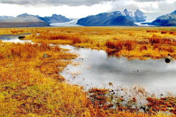
2. J ü kuls á RL ó n glacier lake, also known as J ü kuls á RL ó n, is located at the south end of Vatnaj ü kull glacier. It is the largest and most famous glacier lake in Iceland. The lake is 200 meters deep and is the second largest in Iceland.
Glacial lake
Glacial lake
Glacial lake
Glacial lake
Glacial lake
Glacial lake
Glacial lake
Glacial lake
Glacial lake
Glacial lake
Glacial lake
Glacial lake
Glacial lake
Glacial lake
Glacial lake
Glacial lake
3. Diamond ice beach the southeast entrance of the ice lake of jagul salon. Because the lake has a large amount of water and carries a lot of ice, many ice blocks are pushed onto the black beach by the ocean current, forming a unique landscape of diamond ice beach.
The beach used to be like this, full of ice. With the warming of the climate, there are very few ice cubes now, and you can't see them if you don't go there any more
(internet photo)
8、 Mi Lake area 1, deiti falls, deiti falls in Iceland, is located in the northeast of the Republic of Iceland, J ü kuls á rglj ú fur National Park, MI Lake (M ý The lake area, located in the fyodlem glacier, flows into the J ü kuls á rglj ú fur gorge; Its source is the watner ice field. With a width of about 100 meters and a height of 44 meters, the waterfall is considered to be the highest and most turbulent waterfall in Europe. In summer, the flow can reach 500 cubic meters. It's the location of Prometheus.
Detti falls
Detti falls
Still photo of Prometheus in the film of detti falls:
2. Stora Viti is near karafra volcano. It can be opened to the top of the mountain to see the crater lake. The surrounding scenery with clear lake water is very beautiful. Go to the ridge, one side is the lake, the other side is geothermal.
Stora Crater Lake
Stora Crater Lake
Stora Crater Lake
3. A volcano in Northern Iceland. It was active from 1975 to 1984, during which there were 9 volcanic eruptions. Kravla volcano scenic area is an area with a variety of super fresh volcanic landforms. There are still smoky volcanic cones, lava platforms, lava flows, and hot spots that are still erupting. The sulfur smell in the scenic area is very strong, and you can directly feel the heat inside the earth. It takes about 30 minutes to walk from the parking lot to the foot of the volcano. There are wooden footpaths in the scenic area, which is worth visiting. Google map navigation is wrong. It still navigates to stora crater lake. It's actually in the west of the crater, so it's not too far to walk. We are misled, there is no past, sorry. This is a typical volcanic landform. It's very strange. Upload some online pictures:
4. Namafjall geothermal park is a unique landscape in Iceland
Namafjall geothermal
Namafjall geothermal
Namafjall geothermal
Namafjall geothermal
Namafjall geothermal
Namafjall geothermal
5. GRJ ó tagj á cave this is a small volcanic cave near Mihu lake. There is a blue hot spring in it. The highest temperature of the spring can reach about 50 ℃. There is a sign forbidding visitors to take a hot spring here, but there is no guard. The cave, also featured in the TV series game of thrones, is the "love nest" of Jon Snow and ygritte.
Gadus morhua
Gadus morhua
Still photo of game of rights by GRJ ó tagj á Cave:
6. Huier crater is an extinct volcano in the east of Mihu. It's easy to climb to the crater. The mountain is black and looks like a coal mine. The Icelandic name is hverfjall
Huier crater
Huier crater
Huier crater
Huier crater
Huier crater
7. The dark castle is a labyrinth of scenery formed by the flow of magma. The most famous is the lava arch kirkja, because when a large number of magma flows, the surface has solidified, but the magma inside is still flowing. When the magma flows away, it forms a strange landscape like the arch.
Black Castle
Black Castle
Black Castle
Black Castle
Black Castle
Black Castle
Black Castle
Black Castle
Black Castle
Black Castle
8. Waterfall of God ð Afoss waterfall is located near the famous Mihu Lake in Iceland. It gets its name from a legend. In 999 or 1000 AD, Iceland converted to Christianity, and the Viking gods were thrown into the waterfall. Go ð Afoss is also on the side of the No. 1 Ring Road, which is easy to see.
Waterfall of God
Waterfall of God
Waterfall of God
Waterfall of God
Waterfall of God
Waterfall of God
9. Rhinoceros stone rhinoceros stone is a basalt pile about 15 meters high, standing on the east coast of the vatnsnes Peninsula (northwest Iceland). There are two holes at the bottom of it to make it look like a rhino drinking water. The bottom is covered with existing concrete to protect it from sea water.
Rhinoceros stone
Rhinoceros stone
Rhinoceros stone
Rhinoceros stone
Rhinoceros stone
Rhinoceros stone
Rhinoceros stone
Rhinoceros stone
Rhinoceros stone
Rhinoceros stone
Rhinoceros stone
9、 Mount Sinai Peninsula, a world famous tourist attraction (Icelandic: SN & aelig; Fellsnes), located in the west of Iceland, is about 90 km long, bordering on brezha Bay and huamsfjord in the north and fahsa Bay in the south. 1. West of Church Hill (straw hat Hill) stykkish ó lmur, grundarfj ü R ð The mountain at the mouth of the town is famous for its straw hat shape at some angle. There are also some small waterfalls beside the mountain. Different angles can make different blockbusters, the favorite place for photographers.
Church Hill
Church Hill
Church mountain: thatched Hat Mountain seen from the direction of the hotel:
Church Hill
Church Hill
2. Church mountain waterfall church mountain waterfall has three waterfalls converging down, it and the Big Star Church mountain opposite each other. It has become a landmark scenic spot of Mount Sinai Peninsula. Church Hill waterfall is on the opposite side of the road at the foot of Church Hill. They are all together and do not need to visit separately.
Church Hill waterfall
Church Hill waterfall
Church Hill waterfall
Church Hill waterfall
Church Hill waterfall
3. Anastabi scenic spot, the village of alnastapi, has the most charming small village in Iceland, a series of idyllic houses, crystal clear sea, cliffy coast and mysterious Leifeng, which are arranged at random. They serve as the background and set off each other. Its beauty is wonderful, just look at it is not clear, so. It is not a real village, but a few houses on the edge of the lava area, surrounded by peaks overlooking the vast North Atlantic. Anastabi has the air of condescension, which reminds people that it was once a valuable property of a powerful person and an important port in history. What you can see around you is the natural beauty of Iceland. The rifadaga fissure is like a passage opened by the enemy in the middle of the mountain. The mysterious snow peak of snefax, as well as the bizarre cliff shape on the coast, the blue sea surrounded by rock columns and sea caves, the mini harbor hidden in the middle of the cliff, bring people back to the past of dream fishing village. At the end of the village is a cliff. A road passes through anastabi and leads to the port. Turn right as soon as you get to the port. There is a walking trail along the coast. Along the way, you will find a cave, the top of which has been broken down by the sea. You can see the waves of the sea from below. Many seabirds fight against the waves: it's a bit like the Mediterranean. Further south is the stone arch of gatklettur, which has always been a favorite place for copper plate etchers in the 18th and 19th centuries. They usually visit here.
Alnastapi
Alnastapi
Alnastapi
Alnastapi
Alnastapi
Alnastapi
Alnastapi
Alnastapi
Alnastapi
Alnastapi
Alnastapi
Alnastapi
Alnastapi
Alnastapi
Alnastapi
Alnastapi
Alnastapi
Alnastapi
Alnastapi
Alnastapi
Alnastapi
Alnastapi
4. Sneiffel volcano sneiffel volcano sneiffel is a compound volcano in Western Iceland with a gorgeous ice cap on its head, which is the highest peak in this area. It is often seen in Reykjavik on sunny days. French science fiction writer Jules Verne described mount sneiffel as the entrance to the center of the earth in his book journey to the center of the earth. It has been opened up as a national park. Mount sneiffel is an extinct volcano. Five thousand feet high, it is one of the most famous peaks in Iceland. The volcano has not erupted since 1229. On the top of the mountain, the local Icelanders often call it "mistus". Sneiffel volcano is located in the center of the sneiffel peninsula. Now the top of the mountain is covered with glaciers, just like a sleeping giant. No matter where you are on the peninsula, you can almost always see its huge figure.
Mount sneiffel
10、 Travel information 1. If you are in a city without an Icelandic visa center, you can apply for a Schengen visa from Iceland by submitting to the Danish visa center. However, the application form needs to fill in the Schengen form of Denmark, and the requirements are also very strict. For example, it is required to copy all the pages of the passport. For the first time, it is also required to provide the hotel reservation of the whole journey, and the photo requirements are also very strict. 2. Car rental
It is recommended to use the domestic platform, because the foreign platform, although the car rental fee is very cheap, basically does not include all risks insurance, and to increase the local all risks insurance, the price is usually very expensive. The car rental in Iceland is very expensive. The cost of the Toyota Land Cruiser we rent is about 11000 yuan for 8-day all risks insurance. It is highly recommended to rent a 4WD.
3. The cost of Iceland is very expensive, air tickets, hotels, car rental, shopping, catering and so on. Even going to the toilet costs 12 yuan. Supermarket to buy a cart of food, about 900 yuan, and in Europe, the United States and Canada, the United Kingdom, about 300 yuan. Helpless, others are unique, worth it! Most of the attractions in Iceland are free. Only one bat mountain costs 2000 kronor, about 120 yuan. 4. Road condition Iceland's road condition is not good. Except for the main line around the island, the turning roads are mostly dirt roads and gravel roads. There are also sections that need to wade across the river, so four-wheel drive vehicles are needed. 5. We basically buy and cook our own food. We don't treat Chinese people's taste badly, and it's much cheaper.